
Faszination aus Gotik, Renaissance & Barock
ALTKOLORIERTE KUPFERSTICHKARTE - SEUTTER - um 1750
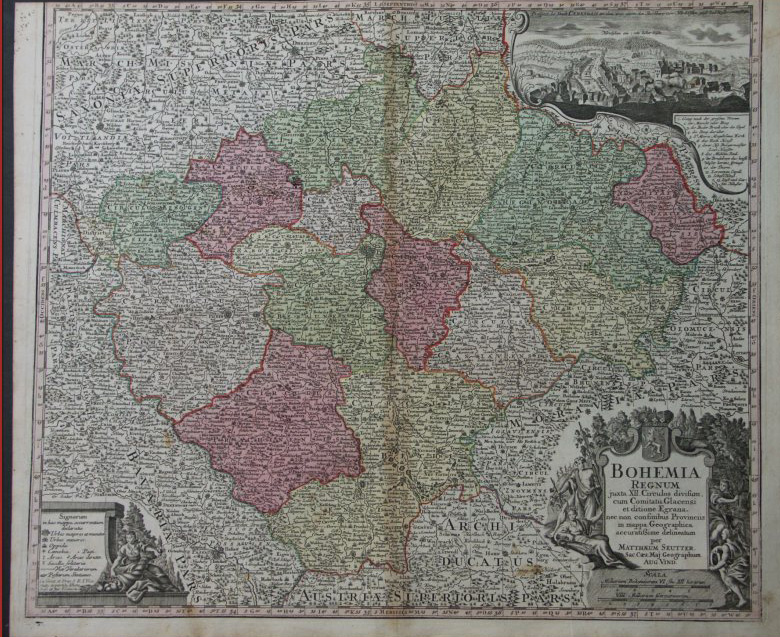
BOHEMIA REGNUM - DAS KÖNIGREICH BÖHMEN
KARTOGRAPH
Matthias Seutter (1678-1756).
Deutscher Kartograf und Kupferstecher sowie Gründer der Druckerei und des Verlages Seutter.
BOHEMIA REGNUM juxta XII. Circulos divisum, cum Comitatu Glacensi et ditione Egrana ...
Mattias Seutter, Augsburg, um 1750.
Originale, altkolorierte Kupferstichkarte des Königreichs Böhmen mit Prag im Zentrum. Die Karte ist begrenzt von den Regionen des Voigtlandkreises, Bayern, Österreich, Mähren und Schlesien.
In der unteren Ecke mit großer allegorischer figürlicher Titelkartusche und aufgesetztem Wappen und Meilenanzeiger sowie figürliche Kartusche mit Legende. In der oberen Ecke befindet sich in einer ornamentalen Kartusche eine kleine Ansicht von Karlsbad mit dem Hirschstein.
ABMESSUNG
Blatt: 60,5 x 50 cm; Platte: 58 x 49,5 cm.
ZUSTAND
In guter Erhaltung. Karte gleichmäßig gebräunt, entlang des Mittelfalzes mit wenigen dünnen Stellen im Papier. Gebräunter Mittelfalz. Im oberen Kartenrand bis an die Skala beschnitten. Schönes, zeitgenössisches Altkolorit.
Hiermit bestätigen wir Originalität sowie einwandfreie Herkunft der vorliegenden Karte. Diese ist zum Zeitpunkt des Verkaufs frei von Rechten Dritter.
Informationen über Versand, Zoll und Ausfuhr finden Sie untenstehend.
TRANSLATION FOR INTERESTED PARTIES
You will find a translation of this description after the detailed photos.
ANSICHT / FOTOS

OLDCOLOURED COPPERENGRAVING MAP BY SEUTTER - c. 1750
BOHEMIA REGNUM
CARTOGRAPHER
Matthias Seutter (1678-1756).
German cartographer and engraver. Founder of the printing house Seutter.
TITLE
BOHEMIA REGNUM juxta XII. Circulos divisum, cum Comitatu Glacensi et ditione Egrana ...
PUBLISHER
Matthias Seutter, Augsburg, c. 1750.
DESCRIPTION
An original, old-coloured copperplate map of the Kingdom of Bohemia, with Prague at its centre. The map is bounded by the regions of the Voigtland district, Bavaria, Austria, Moravia and Silesia.
In the lower corner is a large allegorical cartouche with a coat of arms and a distance marker, as well as a cartouche containing a legend. In the upper corner, an ornamental cartouche features a small view of Karlovy Vary with the Hirschstein.
Leaf: 60,5 x 50 cm; Plate: 58 x 49,5 cm.
In good condition. The map is evenly browned, with a few thin spots in the paper along the central fold. The central fold is browned. Trimmed at the top edge of the map up to the scale. Beautiful, period colouring.
We hereby certify the originality and flawless provenance of the present map. At the time of sale it is free of third party rights.