America Meridionalis per sua regna, provincias et ins. Juxta observation: et descript recenttis divisa et adornata cura et opera. Matth. Seutt. S.C.M. Geogr. Aug. Vind. Cum Privileg: Sac. Rom:Imp. Vicariat. [South America divided into its kingdoms, provinces, and islands]
Antique 18th century copperplate map with original wash colour, c1744
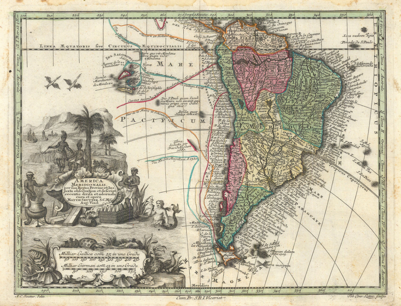
Caption below picture: 'America Meridionalis per sua regna, provincias et ins. Juxta observation: et descript recenttis divisa et adornata cura et opera. Matth. Seutt. S.C.M. Geogr. Aug. Vind. Cum Privileg: Sac. Rom:Imp. Vicariat. [South America divided into its kingdoms, provinces, and islands]'
Antique 18th-century copperplate map of South America by Matthäus Seutter. Original wash colour, enriched with an elaborate allegorical title cartouche depicting regional flora and fauna, maritime emblems, indigenous figures, and a mythical mermaid. The map divides the continent into its principal kingdoms and provinces, with the Andean cordillera finely engraved and the great river systems — the Amazon, Paraguay, and Paraná — prominently delineated. Explorers’ routes are traced, and the mislocated Solomon Islands appear in the Pacific. Off the Chilean coast, a “land discovered by David Anglum in 1680” is noted — likely a cartographic echo of the first European sighting of Easter Island. Intriguingly, within the depths of the Amazon basin appears the label “Village d lOr”, likely a reference to El Dorado, the fabled city of gold long sought by explorers. A richly detailed and visually striking example of early 18th-century European cartography, blending scientific observation with the enduring myths of exploration and discovery.
DATE PRINTED: Undated but circa 1744
IMAGE SIZE: Approx 21.5 x 29.5cm, 8.25 x 11.5 inches (Large); Please note that this is a folding map.
ARTIST/CARTOGRAPHER/ENGRAVER: Published by Matthäus Seutter & Jacob Christoph Weyerman. Albrecht Carl Seutter Delin. Tobias Conrad Lotter Sculp.
PROVENANCE: "Atlas Minor praecipua orbis terrarum imperia, Regna et Provincias, Germaniae Potissimum, tabellis 50 exacte declineatis sistens usui militiae ducum ac peregrinantium maxime accomodatus", opera Matthaei Seutteri, Sac. Caes. Maj. Geogr. Aug. Vind. Jacob Christoph Weyerman ... Cum Privileg: S.R.I. Vicariat. in part: Rheni, Franc: et Suev Juris. (Augsburg)
TYPE: Antique 18th century copperplate map with original wash colour
VERSO: There is nothing printed on the reverse side, which is plain
CONDITION: Good; suitable for framing. Stain in top margin. Please check the scan for any blemishes prior to making your purchase. Please contact us if you would like to arrange to view this map. Virtually all antiquarian maps and prints are subject to some normal aging due to use and time which is not obtrusive unless otherwise stated. I offer a no questions asked return policy - see below.
AUTHENTICITY: This is an authentic historic print, published at the date stated above. I do not offer reproductions. It is not a modern copy. The term 'original' when applied to a print means that it was printed at the first or original date of publication; it does not imply that the item is unique. 'Print' means any image created by applying an inked block to paper or card under pressure by any method including wood engraving, steel engraving, copperplate, wood cut and lithography.
REMARKS: FRANCE: Gravures et Cartes anciennes. DEUTSCHLAND: Alte Lankarten und Stadt ansichten. ITALIA: Stampe e Mappe antiche. ESPAÑA: Mapas antiquos y impresiones antiguas. E and OE. Force Majeure. English law shall apply.
RETURNS POLICY: I offer a no questions returns policy. All I ask is that you pay return shipping and mail back to me in original condition, suitably packed & insured, within 14 days of receipt.