|
|
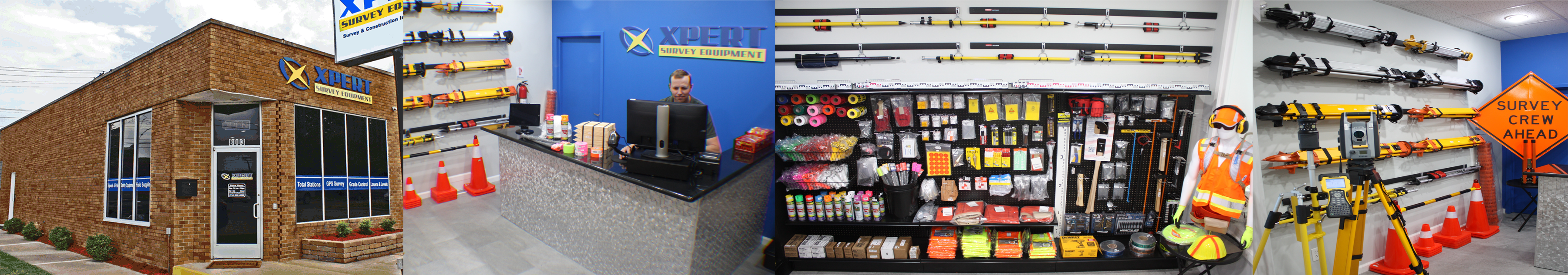
Michigan based company with a global presence. We ship worldwide to thousands of satisfied customers. Offering Same-Day Shipping & pickup for metro Detroit area land surveyors, civil engineers, architects, excavating & construction companies at our local store in Allen Park, MI. Our equipment is backed by exceptional customer service and support, along with a full warranty.
Offering New & Refurbished Total Stations, GPS / GNSS Base & Rovers, Radios, Antennas, Data Collectors, Grade & Pipe Lasers, Digital Levels, Magnetic Locators, Grade Control Systems, AgGPS Systems, Field Supplies, Accessories, Hand Tools & Safety Equipment!
|
|
|
|
|
 |
|
|

|
|
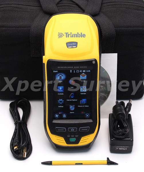
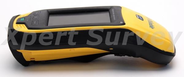
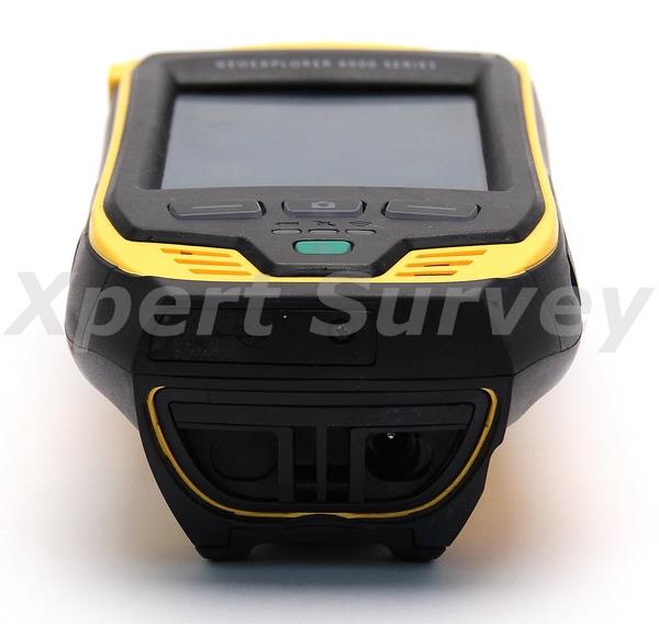
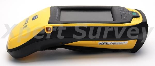
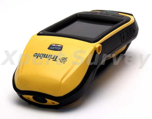
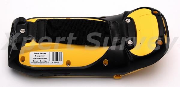
* Trimble Geo Explorer 6000 XH Series Version 3.00.5 w/ Options... [ID- X3499-L/T*]
- Floodlight
- NMEA
- ArcPad V. 10
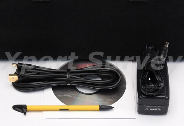
* Stylus
* AC Adapter/Charger
* USB PC Interface Cable
* User Manual On CD-ROM
* Carrying Case (G)
|
|
Condition: Refurbished
Warranty: 90 Day Exchange
|
|
|
|

|
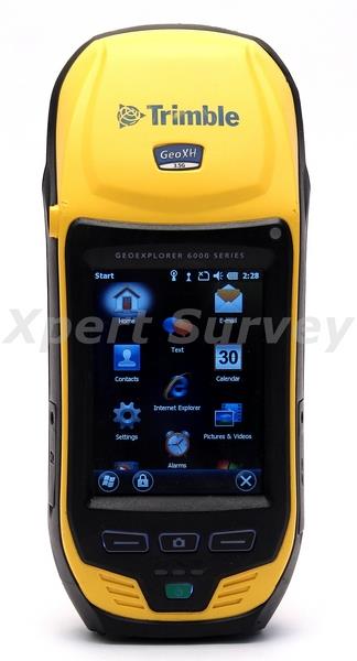
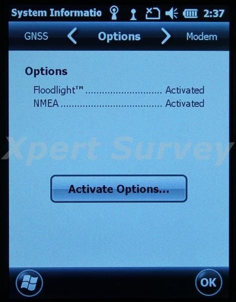
Trimble Geo Explorer 6000 XH Series w/ Options...
- Floodlight
- NMEA
- ArcPad V. 10
Trimble GeoExplorer 6000 Series Geo
The Trimble® GeoExplorer® 6000 series takes GNSS productivity to a whole new level. Bringing together the essential functionality for high-accuracy field work in one device, the GeoXH™ handheld delivers real-time decimeter (10 cm / 4 inch) accuracy positioning and high quality photo capture.
Together with the latest field software enhancements and GNSS innovations—including Trimble Floodlight™ satellite shadow reduction technology—the GeoXH handheld establishes a new standard for GNSS system performance and handheld data capture.
Decimeter accuracy without the wait
For field workers recording the location of buried infrastructure, distinguishing between closely spaced assets, or relocating buried equipment, the GeoXH handheld delivers the accuracy and speed required to ensure that the work of recording new asset locations or navigating back to previously captured assets is fast and reliable.
For field workers recording the location of buried infrastructure, distinguishing between closely spaced assets, or relocating buried equipment, the GeoXH handheld delivers the accuracy and speed required to ensure that the work of recording new asset locations or navigating back to previously captured assets is fast and reliable.
Floodlight satellite shadow reduction
Trees and buildings create satellite shadows, limiting the environments where reliable high- accuracy GNSS data collection can be performed. Using the innovative Trimble Floodlight satellite shadow reduction technology, the GeoXH handheld continues to deliver productive, usable positioning data in areas where legacy GNSS receiver systems cannot.
With Floodlight technology, the GeoXH receiver can compute positions even with very weak satellite signals. Floodlight technology increases the number of positions that are gathered in difficult locations, and boosts accuracy in those places where normally only low accuracy data is available. With the GeoXH handheld, field crews can now work with fewer disruptions, meaning better data, faster, at less cost.
Never-seen-before display performance
The GeoXH handheld includes a sunlight-optimized display designed specifically for outdoor operation. It maintains exceptional clarity in all outdoor conditions, including direct sunlight. Text is crisp and easy to read. Background maps and photos are rich and vibrant. At 4.2" (10.7 cm), the display is also big, so the touch panel is spacious and easy to control.
Work online, anywhere, cable-free
With the GeoXH handheld, wireless connectivity options including cellular, Wi-Fi and Bluetooth® technology ensure that field workers can remain in contact with the office and each other, even from remote locations.
Bluetooth technology also enables wireless connection to other external devices such as Bluetooth-enabled laser range finders, barcode scanners, or underground pipe locators.
High quality photo capture
A photograph is often the best way to capture information about an asset, event, or site. The GeoXH handheld includes a 5 megapixel autofocus camera with geo-tagging capability. The camera can be controlled by the TerraSync™ software and other third-party applications, so photo capture and linking of images to GIS features is seamless and simple to integrate with existing data capture workflows.
Designed for work
The GeoExplorer 6000 series was designed with a single goal in mind—delivering a high-accuracy handheld GNSS system that works faster, longer, and in more places than any other.
The Lithium-Ion battery provides up to 8 hours of GNSS operation on a single charge, and can be swapped on-the-go without shutting down the device—enabling near-continuous operation and minimizing field worker downtime.
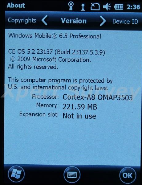
The GeoXH handheld is powered by a super-fast OMAP 3503 series processor and 256 MB RAM. With 2 GB of internal storage and the capacity to add an additional 32 GB via SDHC card, the GeoXH handheld has the capacity and power needed to work with high resolution maps and the most complex datasets.
The fully ruggedized IP65 construction is designed to withstand the harshest environments. Wherever field workers go, they can take the GeoXH handheld with the confidence that the equipment can handle the toughest conditions.
These smart design features combine with unprecedented accuracy and productivity to deliver the ultimate high performance handheld field solution.
Features:
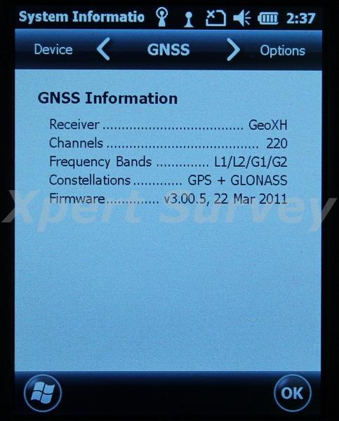
- 220 channel GNSS receiver with real-time H-Star technology
- Decimeter accuracy faster than ever before
- Floodlight satellite shadow reduction technology
- More positions and increased accuracy in tough environments
- Sunlight readable display
- 4.2" polarized screen for unmatched clarity in bright sunlight
- 5 megapixel autofocus camera
- Capture high quality photographs and link directly to features
- High capacity removable battery
- More than 8 hours operation on a single charge and swap-and-go battery replacement in the field
Specifications:
Size And Weight
|
| Height |
234 mm (9.2 in) |
| Width |
99 mm (3.9 in) |
| Depth |
56 mm (2.2 in)
|
| Weight (inc. battery) |
925 g (2.0 lb) |
GNSS
|
Receiver
|
Trimble Maxwell™ 6 GNSS chipset
|
| Channels |
220 channels |
| Systems |
GPS, GLONASS, SBAS |
| GPS |
L1C/A, L2C, L2E |
| GLONASS |
L1C/A, L1P, L2C/A, L2P |
SBAS *1*
|
WAAS/EGNOS/MSAS |
Update rate
|
1 Hz
|
Time to first fix
|
45 s (typical) |
RTCM support
|
RTCM2.x/RTCM3.x |
| CMR support |
CMR/CMR+/CMRx |
GNSS Accuracy (HRMS) After Correction *2*
|
Real-time H-Star *2*
|
10 cm + 1 ppm
|
| Real-time code corrected |
VRS or local base
|
75 cm + 1 ppm
|
| SBAS (WAAS/MSAS/EGNOS) |
< 1 m |
H-Star postprocessed
|
10 cm + 1 ppm |
| Code postprocessed |
50 cm + 1 ppm |
Carrier postprocessed
|
| After 45 minutes |
1 cm + 2 ppm |
| Temperature |
Operation
|
–20 °C to +50 °C (–4 ºF to 122 ºF) |
| Storage |
–30 ºC to +70 ºC (–22 ºF to 158 ºF)
|
| Charging |
0 ºC to +45 ºC (32 ºF to 113 ºF) |
Mechanical Shock
|
| Drop |
1.2 m (4 ft) plywood over concrete |
| Vibration |
Method 514.5 |
Altitude & Humidity Ratings
|
| Relative humidity |
95% non-condensing |
| Maximum operating altitude |
3,658 m (12,000 ft) |
| Maximum storage altitude |
5,000 m (16,400 ft) |
Ingress Protection
|
Water/Dust
|
IP65 |
| Battery |
Type
|
Rechargeable, removable Li-Ion |
| Capacity |
11.1V 2.5 AH |
| Charge time |
4 hours (typical) |
Battery Run Time *3*
|
GNSS only
|
10 hours |
| GNSS & VRS over BT |
9.5 hours |
| GNSS & VRS over Wi-Fi |
8.5 hours
|
| GNSS & VRS over Cellular modem |
5 hours
|
| Standby time |
50 days
|
Buttons & Controls
|
- Power Key
- Left & Right Application Keys
- Camera Key
|
Connectors & Inputs
|
- Internal microphone & speaker
- Mini USB connector
- DE-9 serial via optional USB to serial converter
- External power connector
- SIM socket
- SDHC car socket
|
| Camera |
| Still mode |
Autofocus 5 MP |
| Still image format |
JPG |
| Video mode |
Up to VGA resolution |
| Video file format |
WMV with audio |
Cellular *4* & Wireless *5*
|
| UMTS/HSDPA |
850/900/2100 MHz |
| GPRS/EDGE |
850/900/1800/1900 MHz |
| Wi-Fi |
802.11 b/g |
| Bluetooth |
Version 2.1 + EDR |
| Display |
| Type |
Transflective LED-backlit LCD |
| Size |
4.2" (diagonal) |
| Resolution |
480x640 |
| Luminance |
280 cd/m *2*
|
| Hardware |
| Processor |
TI OMAP 3503 |
| RAM |
256 MB |
| Flash |
2 GB |
| External storage |
SD/SDHC up to 32 GB |
Languages
|
English (US), Spanish, French, German, Italian,
Portuguese (Brazilian), Chinese (Simplified),
Korean, Japanese, Russian |
Software Compatibility
|
- TerraSync™ software
- Trimble GPScorrect™ extension for Esri ArcPad software
- Trimble GPS Controller software
- GNSS Connector software
- GPS Pathfinder® Office software
- Trimble GPS Analyst™ extension for Esri ArcGIS Desktop software
- Third party NMEA-based applications *6*
|
*1* SBAS (Satellite Based Augmentation System). Includes WAAS available in North America only, EGNOS available in Europe only and MSAS available in Japan only.
*2* HRMS refers to Horizontal Root Mean Squared accuracy, 1-sigma (68%). Except in conditions where most GNSS signals are affected by trees, or buildings, or other objects. The following factors increase the availability of specified H-Star accuracy: availability of GPS & GLONASS data at the base station(s) used for corrections, longer elapsed time tracking uninterrupted L1/L2 carrier phase data, use of the optional external Tornado antenna, tracking of more satellites with L2 measurements, shorter distance to the base station(s), and use of more (than one) base stations for postprocessing. Specified H-Star accuracy can normally be achieved for baseline lengths of 100 km or less. H-Star accuracy is typically achieved within 2 minutes. 45 minute carrier postprocessed accuracy is limited to data collected within 10 km of the base station. Except when using VRS corrections, accuracy varies with proximity to base station by +1 ppm for code postprocessing and real-time. Carrier postprocessed accuracy varies with proximity to base station by +2 ppm.
*3* Tested by Trimble with default system settings at 21°C ambient. Actual run time will vary with conditions of use.
*4* 3.5G edition handhelds only. The GeoXH 3.5G edition handheld is PTCRB certified and can operate on supported networks that do not require carrier certification. Consult with your local reseller for more information.
*5* Bluetooth and Wi-Fi type approvals are country specific. GeoExplorer 6000 series handhelds have Bluetooth and Wi-Fi approval in the U.S. and in most European countries. For further information please consult your local reseller.
*6* NMEA output is an optional upgrade.
|
|
|
|
|
|

|
|
We will attempt to ship your item(s) within 24 hours after payment has been received.
Many countries impose their own customs, duties, tariffs, taxes, etc. on items being shipped from a foreign country. We do not cover those cost's and we recommend that you contact your countries customs agency for that information.
|
|
|
|
 |
|

|
|
We accept credit card payment transactions via the online checkout system! The checkout process is designed so that it communicates with the merchant to confirm that payment has been made and cleared. Other methods of payment are outlined through the online checkout process. Winning bidders must contact us within 3 days after auction close if special payment arrangements are needed.
Thank you
|
|
|