1856 Colton Map of Columbia, Venezuela and Ecuador 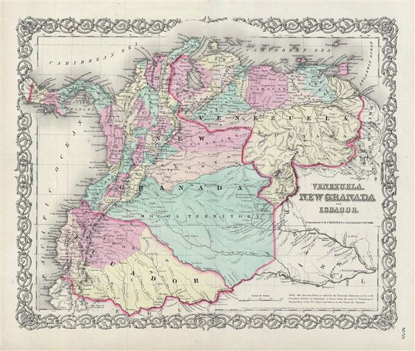 WE SELL ONLY ORIGINAL ANTIQUE MAPS - NOT REPRODUCTIONS Title: Venezuela, New Granada and Ecuador. Description: An excellent 1855 first edition example of Colton's map of Venezuela, New Granada (Colombia), and ecuador. This map covers from the Pacific to Guyana and from Peru to the Caribbean, including Panama. Simon Bolivar's vision of Gran Columbia was proven untenable and in 1829 and 1839, respectively, Venezuela and ecuador became independent nations leading to period of political upheaval and civil war throughout the region. Venezuela dissolved in the bloody Federal War (1859-1863) in which a significant percentage of the population would perish. Colombia became the Confederación Granadina, a short lived federal republic that consisted of modern day Colombia and Panama. The Confederación, facing strong opposition from both liberal and conservative elements, dissolved in 1863 in the midst of the Colombian Civil War (1860 – 1862). This map also identifies various cities, towns, forts, rivers, rapids, mountain passes, fords, and an assortment of additional topographical details. Map is hand colored in pink, green, yellow and blue pastels to define national and regional boundaries. Surrounded by Colton's typical spiral motif border. Dated and copyrighted to J. H. Colton, 1855. Published from Colton's 172 William Street Office in New York City. Issued as page no. 59 in volume 1 of Colton's 1856 Atlas of the World. Size: Printed area measures 14 inches high by 17 inches wide. Condition: Very good. Blank on verso. Even overall toning. Shipping: Shipping rates are not negotiable. Items are shipped within three business days of receiving payment. We are happy to consolidate shipping where possible. The following shipping options are available: 1. FedEx Overnight (45 USD). USA Only. Signature Required. Customs: International buyers are responsible for paying duty and taxes on delivery. DHL or FedEx will contact the buyer by telephone to arrange tax payment if it is levied. Duty varies by country and we cannot predict the amount you will be charged. Some countries are duty free, others are not. Typically, a customs duty and/or VAT tax will be assessed on all parcels to continental Europe. Sometimes duty or tax is due in China, but is seems very random. Hong Kong, Singapore, Korea, and Taiwan have never assessed duty on a map we shipped. Maps shipped to the UK should be duty free as educational materials, but from time to time duty of 5% is assessed incorrectly by the UK customs agents. Insurance: All shipments are insured privately against loss and damage. All of our shipments require a signature for insurance purposes. If you have any questions please feel free to email us through eBay. Other Services Conservation Framing: Geographicus recommends basic conservation framing services for any antique paper. We do not offer this service. |
