1857 U.S. Coast Survey Chart or Map of Plymouth Harbor, Massachusetts 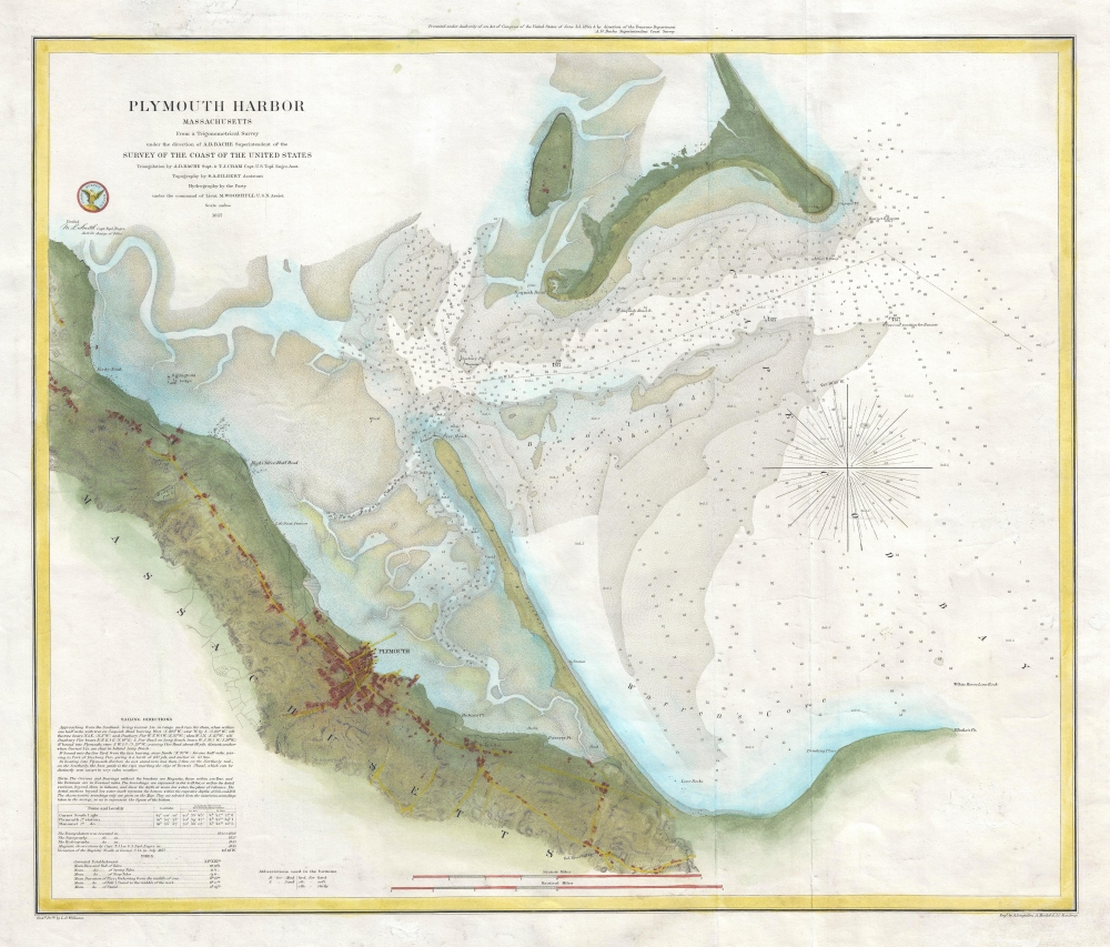 WE SELL ONLY ORIGINAL ANTIQUE MAPS - NOT REPRODUCTIONS Title: Plymouth Harbor Massachusetts. Description: This is a beautiful example of the U.S. Coast Survey's 1857 nautical chart or maritime map of Plymouth Harbor, Massachusetts. The chart depicts the important harbor located just south of Boston near Cape Cod and includes Saquish Head, Clark’s Island and Long Beach. Beautifully detailed coastal features are illustrated and countless depth soundings are noted throughout. Unlike many coastal charts, this example also has significant inland detail, showing roads, towns, farms, and some topographical features. Sailing instructions and notes on tides and magnetic variation appear in the lower left quadrant. The triangulation for this nautical chart was completed by A. D. Bache and T.J. Cram. The Topography is the work of S. A. Gilbert. The hydrography was accomplished by parties under the command of M. Woodhull. The whole was compiled under the supervision of A. D. Bache, one of the most influential American cartographers of the 19th century. This chart is moreover noteworthy in that it is NOT one of the more common charts issued folded into the annual Superintendent's Report, rather it is a separate issue nautical chart on thick stock. Size: Printed area measures 20 inches high by 23.5 inches wide. Condition: Very good. Minor overall toning. Minor foxing. Verso repairs to fold separations. Blank on verso. Shipping: Shipping rates are not negotiable. Items are shipped within three business days of receiving payment. We are happy to consolidate shipping where possible. The following shipping options are available: 1. FedEx Overnight (45 USD). USA Only. Signature Required. Customs: International buyers are responsible for paying duty and taxes on delivery. DHL or FedEx will contact the buyer by telephone to arrange tax payment if it is levied. Duty varies by country and we cannot predict the amount you will be charged. Some countries are duty free, others are not. Typically, a customs duty and/or VAT tax will be assessed on all parcels to continental Europe. Sometimes duty or tax is due in China, but is seems very random. Hong Kong, Singapore, Korea, and Taiwan have never assessed duty on a map we shipped. Maps shipped to the UK should be duty free as educational materials, but from time to time duty of 5% is assessed incorrectly by the UK customs agents. Insurance: All shipments are insured privately against loss and damage. All of our shipments require a signature for insurance purposes. If you have any questions please feel free to email us through eBay. Other Services Conservation Framing: Geographicus recommends basic conservation framing services for any antique paper. We do not offer this service. |
