1958 U.S. Air Force Aeronautical Chart or Map of Hainan Island, China 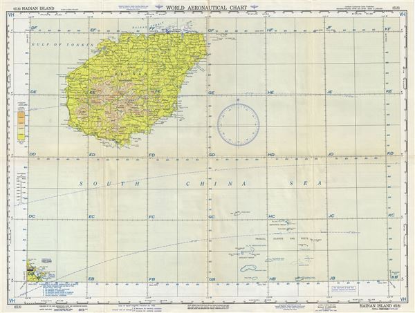 WE SELL ONLY ORIGINAL ANTIQUE MAPS - NOT REPRODUCTIONS Title: Hainan Island China-Vietnam. Description: This is a scarce 1958 U.S. Aeronautical chart or map of Hainan Island, China. It covers the smallest and southernmost province of China, Hainan in its entirety and south as far as the Paracel Islands and Reefs. Vietnam's Da Nang Bay is also included in the lower left quadrant. The map is highly detailed and notes important cities, towns, rivers, roads as well as other hydrographical and topographical features essential for the air pilot. Verso of this chart features legends and a world aeronautical chart index. This chart was published by the USAF Aeronautical Chart and Information Service, Washington 25, D.C., and was issued as chart no. 617. First issued in 1948, this is the sixth edition revised to May 1954. Size: Printed area measures 22 inches high by 29 inches wide. Condition: Very good. Minor wear and toning along original fold lines. Minor spotting. Shipping: Shipping rates are not negotiable. Items are shipped within three business days of receiving payment. We are happy to consolidate shipping where possible. The following shipping options are available: 1. FedEx Overnight (45 USD). USA Only. Signature Required. Customs: International buyers are responsible for paying duty and taxes on delivery. DHL or FedEx will contact the buyer by telephone to arrange tax payment if it is levied. Duty varies by country and we cannot predict the amount you will be charged. Some countries are duty free, others are not. Typically, a customs duty and/or VAT tax will be assessed on all parcels to continental Europe. Sometimes duty or tax is due in China, but is seems very random. Hong Kong, Singapore, Korea, and Taiwan have never assessed duty on a map we shipped. Maps shipped to the UK should be duty free as educational materials, but from time to time duty of 5% is assessed incorrectly by the UK customs agents. Insurance: All shipments are insured privately against loss and damage. All of our shipments require a signature for insurance purposes. If you have any questions please feel free to email us through eBay. Other Services Conservation Framing: Geographicus recommends basic conservation framing services for any antique paper. We do not offer this service. |
