1948 Department of Mines Pictorial Map of the Province of Manitoba 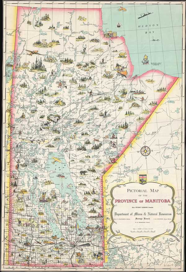 WE SELL ONLY ORIGINAL ANTIQUE MAPS - NOT REPRODUCTIONS Title: Pictorial Map of the Province of Manitoba. Description: This is a c. 1948 Surveys Branch of the Department of Mines and Natural Resources pictorial map of the Canadian province of Manitoba. The map depicts the province from Saskatchewan to Ontario and Hudson Bay and from Nunavut and Hudson Bay to Minnesota and North Dakota. Charmingly illustrated, vignettes of Canadian wildlife, buildings, and outdoor activities populate the entirety of the province. Noose, bears, geese, bison, and other wildlife are illustrated, along with mines and factories. Canadians are pictured fishing, canoeing, sailing, hunting, and trapping, and modern transportation methods, like airplanes, trains, and cars, are also shown. Myriad lakes and rivers are included as well, such as Lake Winnipeg, Lake Manitoba, and Lake Winnipegosis. The road network snakes its way through the southern portion of the province, mostly emanating from Winnipeg, but the roads do not reach much farther north than the 53rd parallel. The Half Moon, Henry Hudson's ship, is pictured in Hudson Bay, alongside a whale and a modern ship. The seal of the Province of Manitoba is situated above the title cartouche along the right side. This map was produced by the Surveys Branch of the Department of Mines and Natural Resources and published c. 1948. Size: Printed area measures 27.25 inches high by 18.5 inches wide. Condition: Very good. Even overall toning. No margins. Blank on verso. Shipping: Shipping rates are not negotiable. Items are shipped within three business days of receiving payment. We are happy to consolidate shipping where possible. The following shipping options are available: 1. FedEx Overnight (45 USD). USA Only. Signature Required. Customs: International buyers are responsible for paying duty and taxes on delivery. DHL or FedEx will contact the buyer by telephone to arrange tax payment if it is levied. Duty varies by country and we cannot predict the amount you will be charged. Some countries are duty free, others are not. Typically, a customs duty and/or VAT tax will be assessed on all parcels to continental Europe. Sometimes duty or tax is due in China, but is seems very random. Hong Kong, Singapore, Korea, and Taiwan have never assessed duty on a map we shipped. Maps shipped to the UK should be duty free as educational materials, but from time to time duty of 5% is assessed incorrectly by the UK customs agents. Insurance: All shipments are insured privately against loss and damage. All of our shipments require a signature for insurance purposes. If you have any questions please feel free to email us through eBay. Other Services Conservation Framing: Geographicus recommends basic conservation framing services for any antique paper. We do not offer this service. |
