1840 S.D.U.K. Map of Polynesia or the Islands in the Pacific Ocean 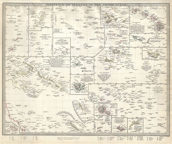 WE SELL ONLY ORIGINAL ANTIQUE MAPS - NOT REPRODUCTIONS Title: Polynesia or Islands in the Pacific Ocean. Description: This is a fine example of the 1840 Society for the Diffusion of Useful Knowledge or S.D.U.K. map of the islands of the Pacific Ocean or Polynesia. Essentially twenty maps on one sheet, it covers the Mariana Islands or Ladrones, the Pelew Islands or Palaos, Gilbert Islands or Scarborogh Range, Otdia or Romanzoff Group, Marshall Islands, Galapagos Islands, Marquesas or Mendana Archipelago, Sandwich Islands, Samoa or Navigator Islands, Tonga-Tabou Islands, Tonga or Friendly Islands, Fiji Islands, Santa Cruz Island, Vanikoro Island, The Low Archipelago, Otaheite or Tahiti, Cooks or Hervey Isles, Pitcairn Island, Juan Fernandez, Norfolk Island and, in a large inset, the Admiralty Isles, New Ireland or Tombara, New Britain or Birara and Salomon Islands. Also notes the dates of discovery as well as the dates the islands were ceded or settled by the British. This map was originally copyrighted in 1840, but was issued in Volume two of Chapman and Hall's 1844 edition of Maps of the Society for the Diffusion of Useful Knowledge. It was engraved by John Walker of J. and C. Walker. Size: Printed area measures 13 inches high by 16 inches wide. Condition: Very good. Bears University of California Library Stamp, from which it was deaccessioned, in lower right quadrant. Blank on verso. Shipping: Shipping rates are not negotiable. Items are shipped within three business days of receiving payment. We are happy to consolidate shipping where possible. The following shipping options are available: 1. FedEx Overnight (45 USD). USA Only. Signature Required. Customs: International buyers are responsible for paying duty and taxes on delivery. DHL or FedEx will contact the buyer by telephone to arrange tax payment if it is levied. Duty varies by country and we cannot predict the amount you will be charged. Some countries are duty free, others are not. Typically, a customs duty and/or VAT tax will be assessed on all parcels to continental Europe. Sometimes duty or tax is due in China, but is seems very random. Hong Kong, Singapore, Korea, and Taiwan have never assessed duty on a map we shipped. Maps shipped to the UK should be duty free as educational materials, but from time to time duty of 5% is assessed incorrectly by the UK customs agents. Insurance: All shipments are insured privately against loss and damage. All of our shipments require a signature for insurance purposes. If you have any questions please feel free to email us through eBay. Other Services Conservation Framing: Geographicus recommends basic conservation framing services for any antique paper. We do not offer this service. |
