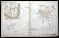
Map #009 / NOT A COPY OR REPRINT!!
Printed in 1892, loose, and never bound! This is an original map from the "Atlas to Accompany the Official Records of the Union and Confederate Armies"
Includes inset maps of:
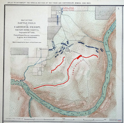
1. Map of the Battle-Field of Carnifix Ferry, Gauley River West, VA. 2. Sketch of the Country about SomerSet, KY. 3. Military Reconnaissance, Vicinity of Gauley Bridge, Department of Western Virginia.
When the US War Department began issuing its 70 volume set of records generated by both the Union and Confederate Armies, it also created an Atlas to Accompany the Official Records. The atlas was published in 35 sections, from 1891-1895. It contained 175 loose plates with more than 1,000 maps, illustrations, and diagrams, detailing battlefield maps, scenes from the conflict, and military equipment. This map comes from that atlas.
Published by a Resolution of the U.S. Congress of May 19, 1864 as The Official Historical Record of The Civil War, and was never openly sold, but distributed only to Federal depositories, university libraries, public museums, various public & semi-public concerns. Fewer than 1,000 complete atlases rare said to remain.
This large map measures 29.5" wide and 18.5" tall.
This map is fresh from a local estate, and is in original as-found condition, with absolutely no repairs. It has spent it's entire life folded and stored away, out of sunlight, and has never been displayed.
It will flatten and frame beautifully.
Except for some scattered chips and minor paper-loss at edges and corners, there are absolutely no rips, tears, holes, writing, library stamps, hidden damage, or repairs. Single vertical fold, as issued.
Guaranteed to be an original 1800's map, not a reproduction or reprint.