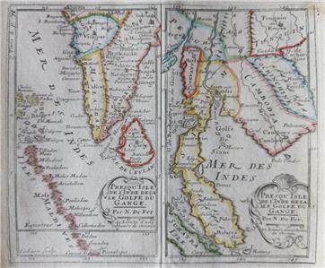
An ORIGINAL map from the late 17th century
PRESQU'ISLE DE L'INDE DECA LE GOLFE DU GANGE
-
PRESQU'ISLE DE L'INDE DELA LE GOLFE DU GANGE
by
Nicolas de Fer
From Robbe - Methode pour apprendre facilement la Géographie. 1695,
I will provide a copy of title page
- Original 17th century copperplate engraved map with centre fold as issued
- Printed on one side only (blank reverse)
- Later hand coloring
Image size
5.3" x 6.2" (135 x 158 mm), plus margins.
Shipping / Handling
Priority airmail with tracking $10
Multiple items are shipped together
ALL ITEMS ARE GENUINE
Thanks for interest