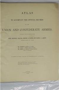
ATLAS TO ACCOMPANY THE OFFICIAL RECORDS OF THE UNION AND CONFEDERATE ARMIES
PUBLISHED UNDER THE DIRECTION OF THE HONS. REDFIELD PROCTOR, STEPHEN B. ELKINS, AND DANIAL S. LAMONT
Secretaries of War
By Major George B. Davis, U.S. Army; Mr. Leslie J. Perry, Civilian Expert; and Mr. Joseph W. Kirkley, Civilian Expert
Board of Directors
COMPILED BY CAPTAIN CALVIN D. COWLES, 2nd U.S. INFANTRY
FIRST EDITION
FINE - CONDITION
Original, Clean, Bright, Antique Civil War Map and Illustration Collection
Complete Set of 178 Plates, High Quality, Maps and Illustrated Plates and Associated Materials
Some Plates are Full Color; Unit Locations and Forts Shown for Union and Confederate Forces
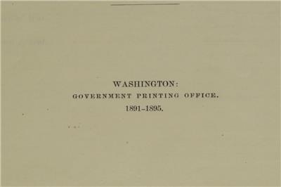
PUBLISHED BY THE GOVERNMENT PRINTING OFFICE, WASHINGTON, D.C., IN 1891-1895
HOWE C-822
This is a complete, first edition, antique book set of the Atlas to Accompany the Official Records of the Union and Confederate Armies. This extraordinary collection includes all the original, 178 plates (Plate 135 has additional plates 135A, 135B, and 135C), high-quality, antique, maps and illustration plates, and the complete Atlas index.
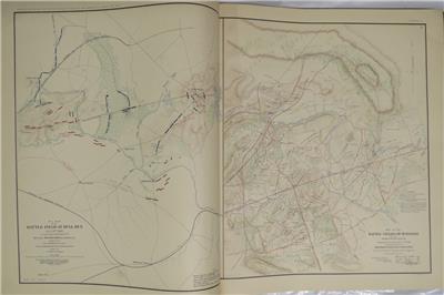
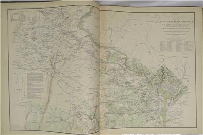
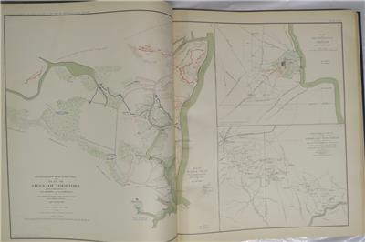
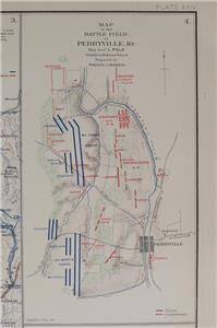
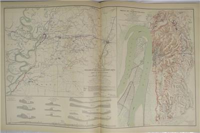
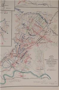
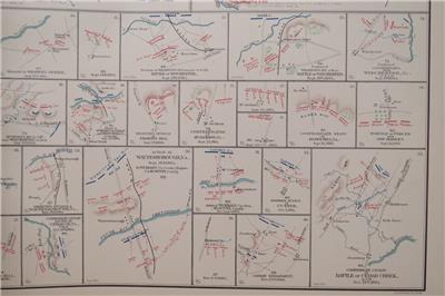
This is the nicest set of these maps and illustrations I have seen. They are bright and sharp. The maps contain unit locations of both Union and Confederate forces indicated in color on the maps as well as details of terrain. Some plates are in full color.
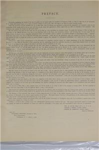
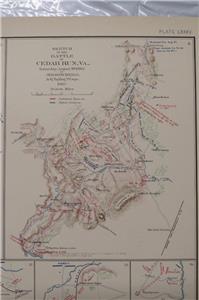
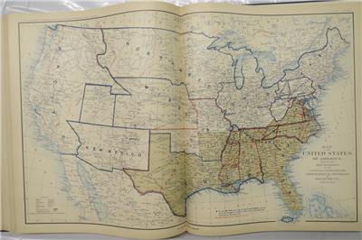
“After the Civil War, the U.S. Government and the Army embarked on a landmark joint endeavor. For the first time in American history, the federal government itself – led by the Army – compiled a military history. The history was composed of all the official military documents from both sides of the war, and it proved to be a massive production. It was called War of the Rebellion: A Compilation of the Official Records of the Union and Confederate Armies, and referred to as Official Records or the O.R. It contained official reports, letters, telegrams strength returns, and casualty lists, covering all theaters throughout the war. The Army then gathered the official military maps to supplement the O.R. and called it The Atlas to Accompany the Official Records of the Union and Confederate Armies. The maps had been drawn during the war by engineers, draftsmen, and sometimes even generals themselves for actual military use. Only a few maps, drawn later by cartographers, were added for historical purposes. Tactical and strategic maps indicate troops dispositions; defense lines, redoubts, and fortifications of key sites are clearly shown. Terrain maps often contain picket positions, signal stations, and lines of march. Some are rough sketches, some cartographic masterpieces. All are informative and reveal the knowledge – or lack of knowledge – that both sides possessed about the terrain, and the strength and the position of opposing troops. The index to the maps is an invaluable aid. It refers to campaigns and battles, rivers, creeks, lakes bays, islands, bridges, fords, ferries, landings, roads, railroads, mountains, towns, churches, forts, and much more. The atlas is an indispensable tool for both historical and Civil War buff. The Official Military Atlas not only adds to an understanding of the Civil War, but is vital to a complete understanding.”
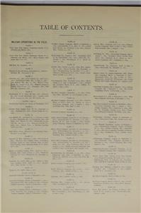
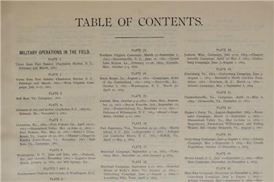
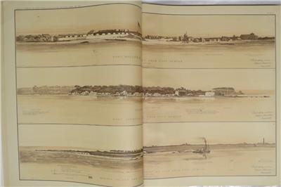
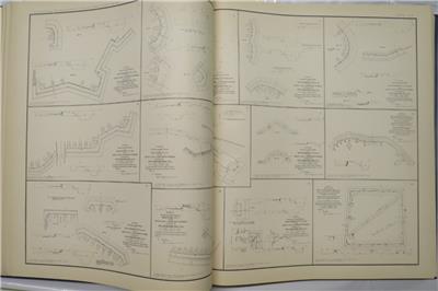
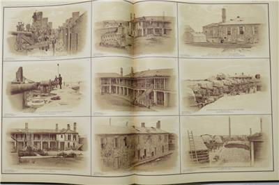
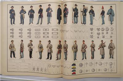
The set includes the complete index. Plates 1 to 135-C are of Military Operations in the Field, Plates 136 to 161 are of General Topographical Maps, Plates 162 to 171 are to Military Divisions and Departments, Plates 172 to 175 are of Miscellaneous items including scenes, uniforms, military equipment, flags and standards, and more.
THIS MAP SET IS IN FINE - CONDITION
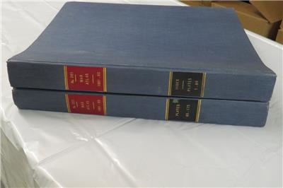
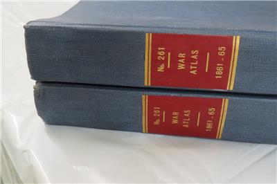
Uncommon. This is truly an excellent condition, first edition, complete set of the Atlas to Accompany the Official Records of the Union and Confederate Armies. Almost all maps are in fine condition. Those that aren't are in fine - condition due only to a very few having a couple, very small edge chips. Well above average. Overall this is the finest set I have seen in over 25 years of antique book selling. The maps and illustrations are in excellent, clean, sharp, bright condition. They have been well protected by the two, sturdy, binding covers. The exterior binders are in light blue cloth covers with bright gold lettering and highlights on blue and red spine backgrounds. The have very light aging to the exterior and a small ship to one spine back ground; they are strong and sturdy. They measure 18 ½ inches by 15 ¾ inches by 1 7/8 inches. The An excellent condition, first edition, complete set.
ORIGINAL, ANTIQUE, FIRST EDITION, COMPLETE SET OF THE ATLAS TO ACCOMPANY THE OFFICIAL RECORDS OF THE UNION AND CONFEDERATE ARMIES
ATLAS TO ACCOMPANY THE OFFICIAL RECORDS OF THE UNION AND CONFEDERATE ARMIES PUBLISHED UNDER THE DIRECTION OF THE HONS. REDFIELD PROCTOR, STEPHEN B. ELKINS, AND DANIAL S. LAMONT Secretaries of War
By Major George B. Davis, U.S. Army; Mr. Leslie J. Perry, Civilian Expert; and Mr. Joseph W. Kirkley, Civilian Expert
Board of Directors
COMPILED BY CAPTAIN CALVIN D. COWLES, 2nd U.S. INFANTRY
FIRST EDITION
FINE - CONDITION Original, Clean, Bright, Antique Civil War Map and Illustration Collection
Complete Set of 178 Plates, High Quality, Maps and Illustrated Plates and Associated Materials
Some Plates are Full Color; Unit Locations and Forts Shown for Union and Confederate Forces
PUBLISHED BY THE GOVERNMENT PRINTING OFFICE, WASHINGTON, D.C., IN 1891-1895 HOWE C-822
This is a complete, first edition, antique book set of the Atlas to Accompany the Official Records of the Union and Confederate Armies. This extraordinary collection includes all the original, 178 plates (Plate 135 has additional plates 135A, 135B, and 135C), high-quality, antique, maps and illustration plates, and the complete Atlas index.
This is the nicest set of these maps and illustrations I have seen. They are bright and sharp. The maps contain unit locations of both Union and Confederate forces indicated in color on the maps as well as details of terrain. Some plates are in full color.
“After the Civil War, the U.S. Government and the Army embarked on a landmark joint endeavor. For the first time in American history, the federal government itself – led by the Army – compiled a military history. The history was composed of all the official military documents from both sides of the war, and it proved to be a massive production. It was called War of the Rebellion: A Compilation of the Official Records of the Union and Confederate Armies, and referred to as Official Records or the O.R. It contained official reports, letters, telegrams strength returns, and casualty lists, covering all theaters throughout the war. The Army then gathered the official military maps to supplement the O.R. and called it The Atlas to Accompany the Official Records of the Union and Confederate Armies. The maps had been drawn during the war by engineers, draftsmen, and sometimes even generals themselves for actual military use. Only a few maps, drawn later by cartographers, were added for historical purposes. Tactical and strategic maps indicate troops dispositions; defense lines, redoubts, and fortifications of key sites are clearly shown. Terrain maps often contain picket positions, signal stations, and lines of march. Some are rough sketches, some cartographic masterpieces. All are informative and reveal the knowledge – or lack of knowledge – that both sides possessed about the terrain, and the strength and the position of opposing troops. The index to the maps is an invaluable aid. It refers to campaigns and battles, rivers, creeks, lakes bays, islands, bridges, fords, ferries, landings, roads, railroads, mountains, towns, churches, forts, and much more. The atlas is an indispensable tool for both historical and Civil War buff. The Official Military Atlas not only adds to an understanding of the Civil War, but is vital to a complete understanding.”
The set includes the complete index. Plates 1 to 135-C are of Military Operations in the Field, Plates 136 to 161 are of General Topographical Maps, Plates 162 to 171 are to Military Divisions and Departments, Plates 172 to 175 are of Miscellaneous items including scenes, uniforms, military equipment, flags and standards, and more.
THIS MAP SET IS IN FINE - CONDITION
Uncommon. This is truly an excellent condition, first edition, complete set of the Atlas to Accompany the Official Records of the Union and Confederate Armies. Almost all maps are in fine condition. Those that aren't are in fine - condition due only to a very few having a couple, very small edge chips. Well above average. Overall this is the finest set I have seen in over 25 years of antique book selling. The maps and illustrations are in excellent, clean, sharp, bright condition. They have been well protected by the two, sturdy, binding covers. The exterior binders are in light blue cloth covers with bright gold lettering and highlights on blue and red spine backgrounds. The have very light aging to the exterior and a small ship to one spine back ground; they are strong and sturdy. They measure 18 ½ inches by 15 ¾ inches by 1 7/8 inches. The An excellent condition, first edition, complete set.
ORIGINAL, ANTIQUE, FIRST EDITION, COMPLETE SET OF THE ATLAS TO ACCOMPANY THE OFFICIAL RECORDS OF THE UNION AND CONFEDERATE ARMIES