'Republic of Ireland - South Coast - Waterford Harbour'
Large British nautical sea chart. Sea charts such as this were working navigational aids which were commonly updated and corrected during their working lives by hand annotation and/or printed overlays. They may also feature manuscript navigational notes, comments or other markings, 1978 (1990)
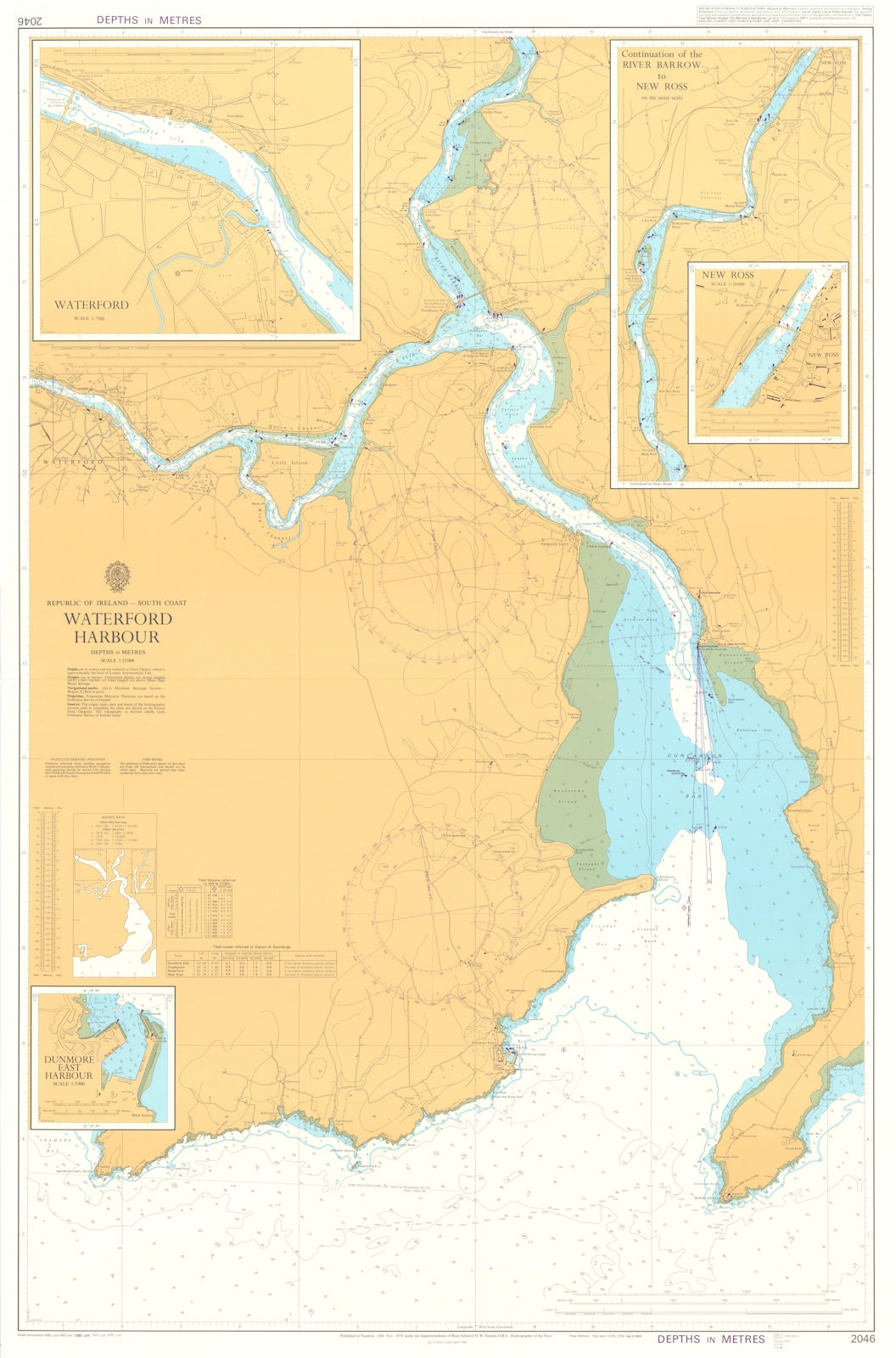
Caption below picture: 'Republic of Ireland - South Coast - Waterford Harbour'
DATE PRINTED: First published 1978. This edition 1984. Small corrections to 1990
IMAGE SIZE: Approx 105.0 x 69.0cm, 41.5 x 27 inches (Large); Please note that this is a folding map.
ARTIST/CARTOGRAPHER/ENGRAVER: Published at the Admiralty under the superintendence of Rear Admiral Sir David Haslam
PROVENANCE: Published at the Admiralty. Crown Copyright reserved. This map was previously in the possession of Royal Navy Navigating Officer Ian Inskip, Falklands War veteran
TYPE: Large British nautical sea chart. Sea charts such as this were working navigational aids which were commonly updated and corrected during their working lives by hand annotation and/or printed overlays. They may also feature manuscript navigational notes, comments or other markings
VERSO: There is nothing printed on the reverse side, which is plain
CONDITION: Good; suitable for framing. Please check the scan for any blemishes prior to making your purchase. Virtually all antiquarian maps and prints are subject to some normal aging due to use and time which is not obtrusive unless otherwise stated. I offer a no questions asked return policy - see below.
AUTHENTICITY: This is an authentic historic print, published at the date stated above. I do not offer reproductions. It is not a modern copy. The term 'original' when applied to a print means that it was printed at the first or original date of publication; it does not imply that the item is unique. 'Print' means any image created by applying an inked block to paper or card under pressure by any method including wood engraving, steel engraving, copperplate, wood cut and lithography.
REMARKS: FRANCE: Gravures et Cartes anciennes. DEUTSCHLAND: Alte Lankarten und Stadt ansichten. ITALIA: Stampe e Mappe antiche. ESPA�A: Mapas antiquos y impresiones antiguas. E and OE. Force Majeure. English law shall apply.
RETURNS POLICY: I offer a no questions returns policy. All I ask is that you pay return shipping and mail back to me in original condition, suitably packed & insured, within 14 days of receipt.