|
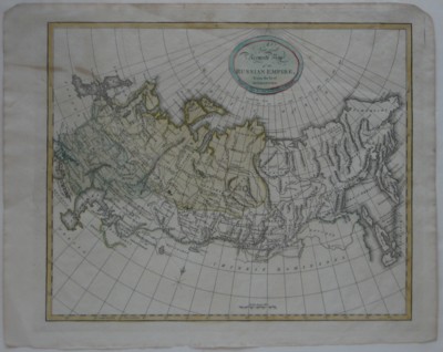
Original 1801 Map RUSSIAN EMPIRE Tsar Alexander I Kamchatka Petersburg Moscow
Genuine
original antique copper engraved map of the Russian Empire with
decorative swash title,
printed more than 210 years ago.
The map was engraved by Samuel Neele and published by Thomas Brown in
his General Atlas,
Edinburgh, 1801. The image area measures 27.2 x 33 cm [10¾" x 13"], and
the distance
scale is measured in British statute miles.
Thomas Brown was an Edinburgh bookseller and publisher of the late 18th
and early 19th century.
The map is titled A New and Accurate Map of the Russian
Empire, from the best
Authorities.
It depicts the Russian Empire shortly after the reign of Catherine
the Great,
the most renowned and the longest-ruling female leader of Russia, who
governed
during what is considered to be its
Golden Age. Her grandson, Tsar Alexander I ascended to the throne
following the assasination of this father Paul I in
1801, the year this
map was printed.
Among the details on the map is a printed note locating the "Wintering
of the Dutch in 1596,"
refering to the explorations of Willem Barentsz along the coast of Nova
Zembla. Other details
include Kamchatka, Petersburg, the Ural Mountains, the Maimatschin
"Trading Place" on the
northern border of China, the Schelkovo "Silk Manufactory," Musqua
(Moscow), and dozens of rivers, cities, and
settlements.
Condition: This map is in very good condition,
with generous margins and no
rips or tears. There are two faint spots in the upper left corner, and
the map is blank
on the back, with no printing on the reverse side. Please see the
scans, including the one below of the full sheet, and feel free to ask
any questions.
This is an original, authentic antique map, not
a reproduction or modern reprint. It is fully guaranteed to be genuine.
We are pleased to offer it
with
our unconditional, money-back guarantee.
|
