Garmin Authorized Dealer – GPSCity.com
❤️ Like our gear? Add GPS City to your Saved Sellers using the seller box on this page.
SHOP ALL SEND US A MESSAGE SHOP CURRENT DEALS

This Garmin Tread Overlander Edition comes directly from Garmin’s official recertification program. GPS City is one of the few authorized sellers able to offer them.


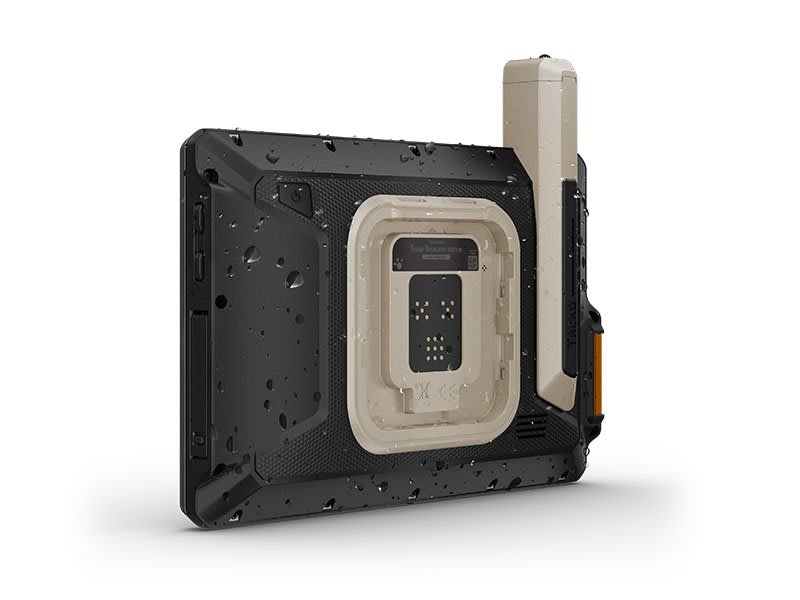
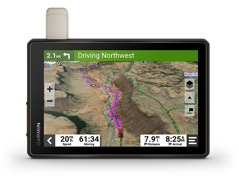
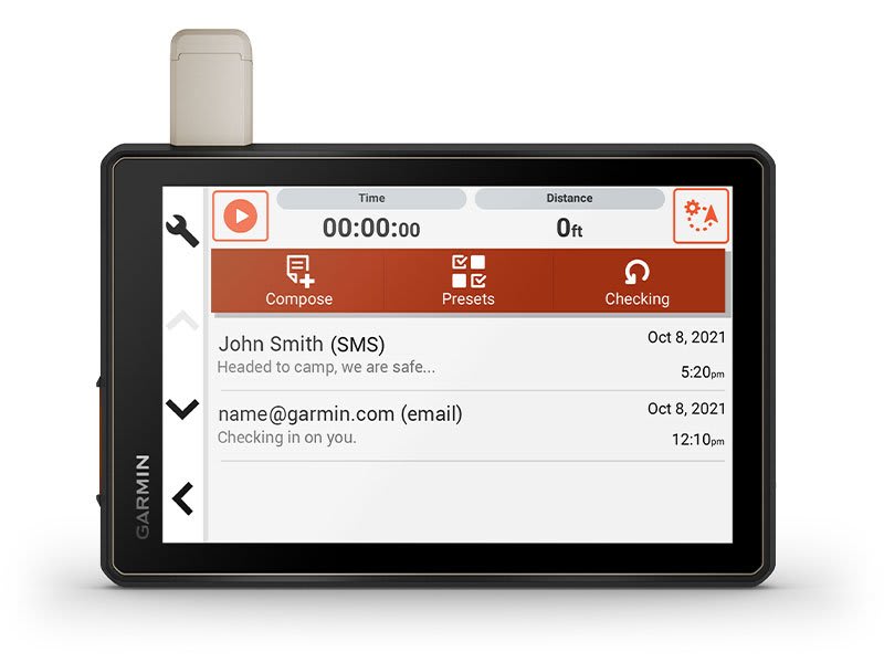
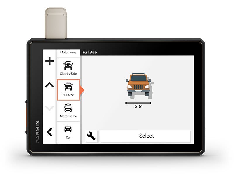
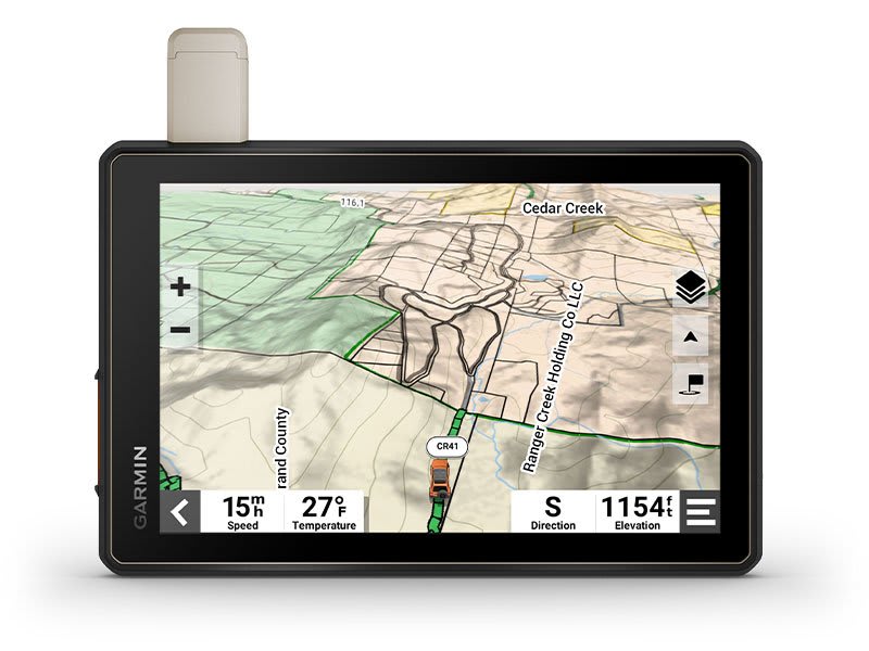
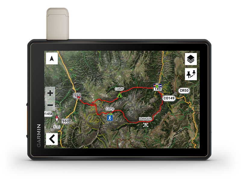
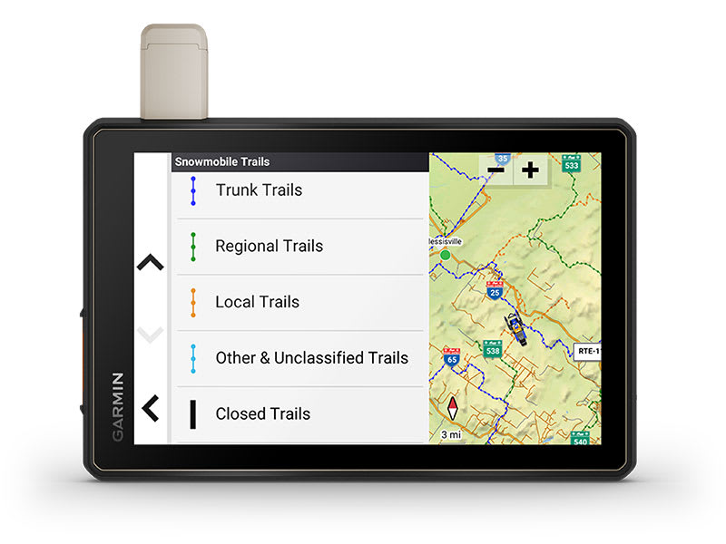
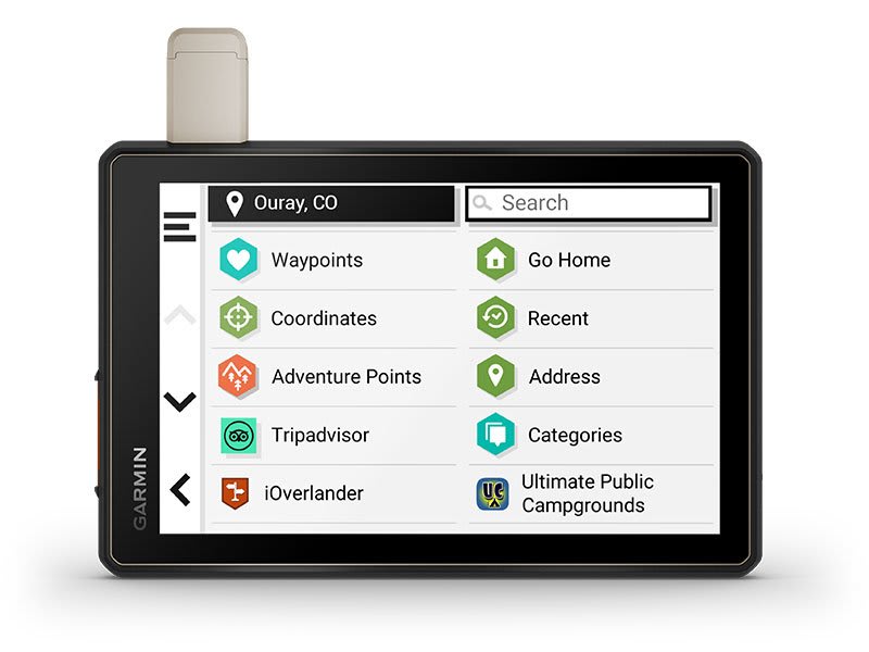
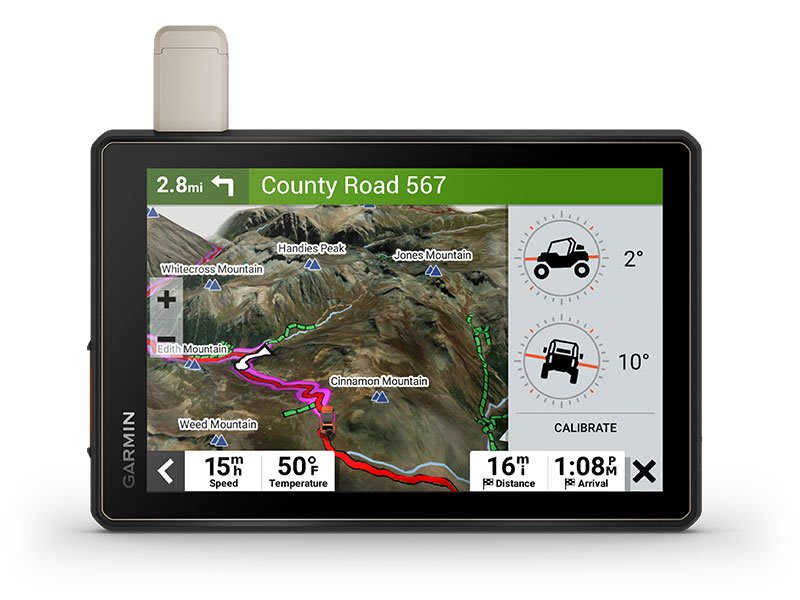
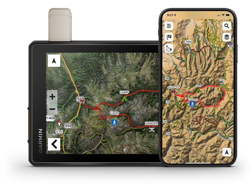
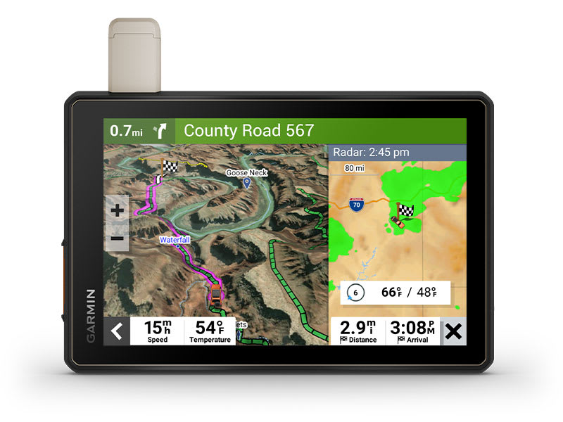
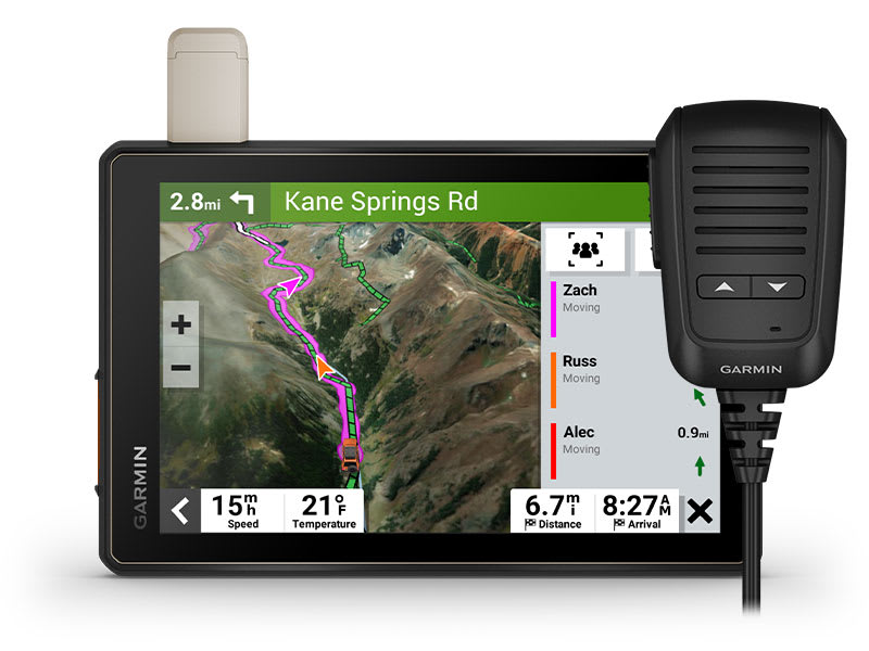
Garmin Tread Overlander Edition Rugged All-Terrain Navigator with Built-In inReach and 8” Touchscreen

Part Number: 010-02508-00

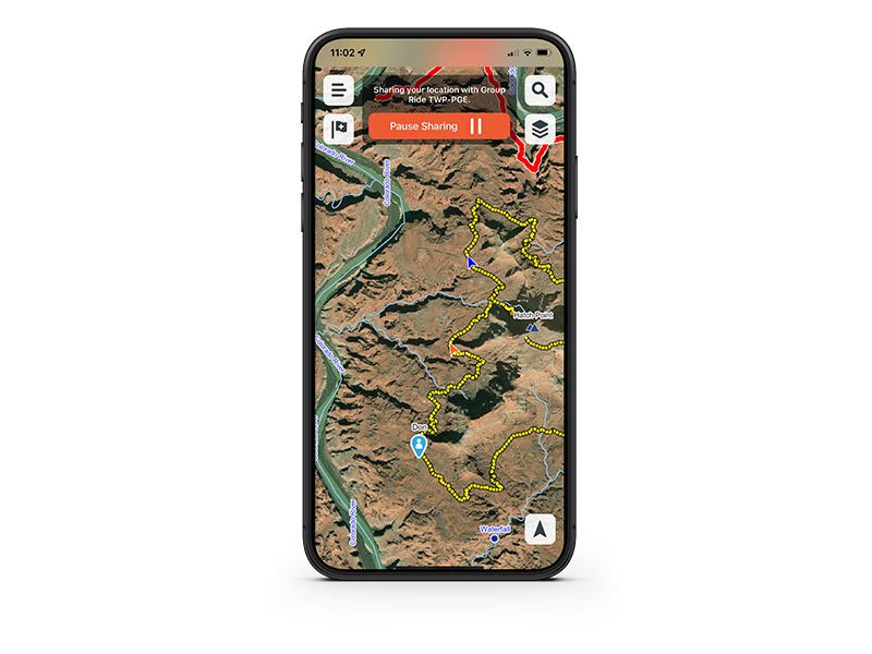
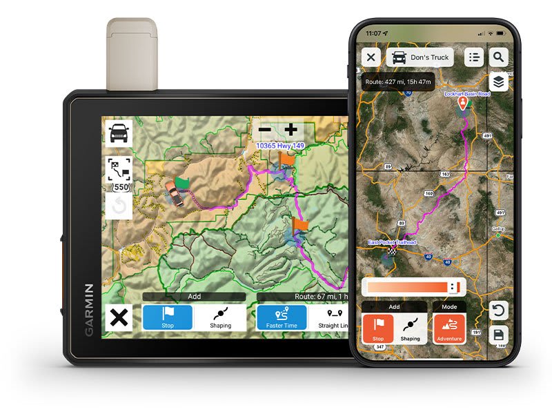
Condition: Garmin Certified Refurbished. This Garmin Tread Overlander Edition comes directly from Garmin’s official recertification program. Each navigator is individually inspected, cleaned, updated and tested by Garmin technicians, then repackaged to look and feel as close to new as possible; all backed by a full Garmin warranty. You get rugged on- and off-road navigation plus built-in inReach satellite communication — all while saving compared to new retail.

Why Buy From GPS City?

  • Garmin Certified Recertified Device
  • 1-Year Garmin Warranty – manufacturer-backed
  • Like-New Condition – extensively tested by Garmin
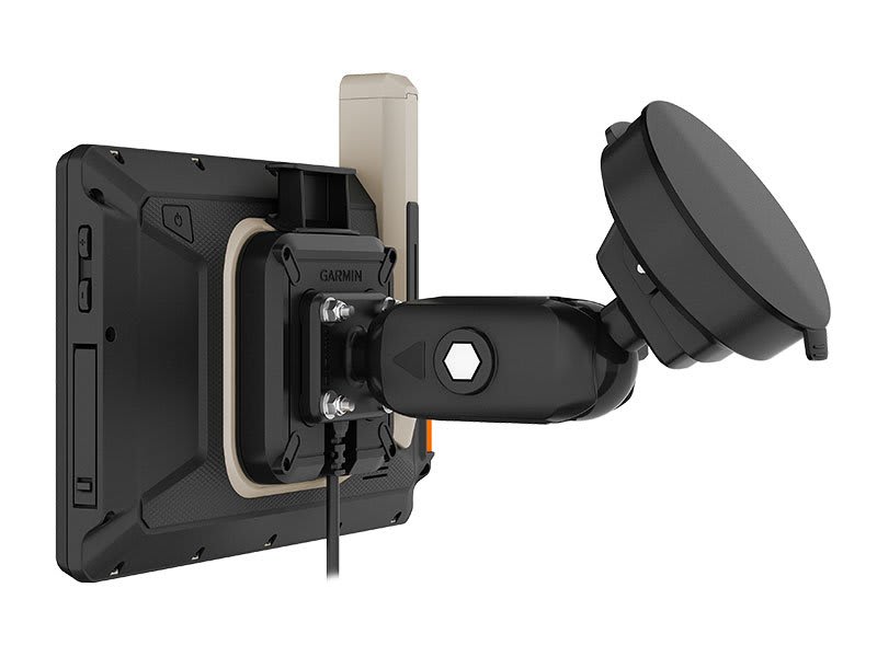
  • Full Kit Included – see “What’s in the Box?”
  • Trusted Garmin Specialists – experts since 1994
  • Fast USA Shipping – same or next business day
  • Established Seller with decades of experience
  • Easy Returns & real product support if you need help

What is a Garmin Recertified Device?

Garmin® Recertified devices are products that have been returned to Garmin for a variety of reasons. These returned devices go through a recertification process that includes an extensive testing procedure to bring them up to the same specifications as when they were manufactured as new, maintaining our high-quality Garmin standards.

A recertified device that is purchased from an authorized Garmin dealer will come with a one-year manufacturer’s warranty. Note that some devices may have a longer warranty period than one year.

📝 Manufacturer Description

DON’T ARRIVE AT YOUR DESTINATION. DISCOVER IT.
Built for every part of the journey, this rugged all-terrain navigator has the mapping you need to stay on track and communication technology to stay in touch while you’re out there.
Navigate unpaved roads and trails by using turn-by-turn trail navigation1 with OpenStreetMap (OSM) and USFS Motor Vehicle Use Maps.
Custom routing for the size and weight of your rig2 and preloaded iOverlander points of interest (POIs) help you find where to set up camp.
This rugged navigator is IP67 weather-resistant and has an 8” ultrabright touchscreen display.
See vivid aerial views of terrain with downloadable, subscription-free BirdsEye Direct Satellite Imagery.
Use the Tread® app on your compatible smartphone to sync data across your various devices and plan routes.
Peace of mind comes built-in. With an active subscription, you can use inReach® technology for global satellite communication.

OFF-ROAD RUGGEDNESS

Purpose-built for all-terrain use, this Tread device stands up to anything the elements can throw at it. It’s IP67-rated for water-resistance.

HIGH-VISIBILITY DISPLAY

With its ultrabright 8” glove-friendly touchscreen, the navigator is designed for easy viewing in bright sunlight or pitch dark. It can be mounted in portrait or landscape mode.

TRAIL NAVIGATION

Enjoy turn-by-turn trail navigation for traversing unpaved roads and trails using adventure roads and trails map content comprised of OSM and USFS Motor Vehicle Use Maps.1

BUILT-IN INREACH TECHNOLOGY

Built-in inReach technology offers global satellite communication3, two-way text messaging, location sharing and interactive SOS (active satellite subscription required).

MAPS ON AND OFF-ROAD

Tread includes preloaded topographic maps with 3D terrain for North and South America. It also includes detailed street maps of North America with custom routing for the size and weight of your rig.2

KNOW YOUR BOUNDARIES

Access U.S. public land boundaries for national forests, Bureau of Land Management (BLM), wilderness areas and more. Also, see U.S. private land boundaries and landowner information for parcels greater than 4 acres.

SATELLITE IMAGERY

Enjoy vivid aerial views when you download high-resolution BirdsEye Direct Satellite Imagery directly to your device via Wi-Fi® connectivity, with no annual subscription required.

TRAIL RATINGS

Our growing trail database now includes difficulty ratings for off-road riding areas, where available, across the U.S.

SNOWMOBILE TRAILS

View snowmobile trail content for select areas within the U.S. and in Canadian provinces. This includes snowmobile-accessible locations such as fuel stops, warming shelters, restaurants and more.

OUTDOOR MAPS+

With a paid Outdoor Maps+ subscription, you’ll get ongoing access to a wide variety of additional premium map content. It is regularly updated and delivered directly to your Tread device via Wi-Fi® connectivity.

POINTS OF INTEREST

Tread comes preloaded with iOverlander points of interest and Ultimate Public Campgrounds, so you don’t need a cell signal to route to the best-established, wild and dispersed campsites.

ABC SENSORS

When you’re headed to tough-terrain, the built-in sensors will come in handy — including an altimeter, barometer, compass and pitch/roll gauges.

SECURE MOUNT

Use the included locking magnet-assisted mount to secure the navigator to your vehicle.

GROUP RIDE MOBILE

Track friends from your compatible smartphone or Tread device when you and your friends use the Tread app’s Group Ride Mobile feature.

EASY ROUTE PLANNER

Use the Tread app to easily plan routes with the same maps, vehicle profiles and route preferences that you have on the Tread device.

EASILY SYNC YOUR DEVICES

Use the Tread app to sync waypoints, tracks, routes and collections across all your devices. Easily import and share GPX files, too.

LIVE WEATHER

Weather ahead? Pair your Tread device with your compatible smartphone, and download the Tread app to access live weather, storm alerts, animated radar and more.

CONTROL YOUR ACCESSORIES

Pair Tread with the compatible Garmin PowerSwitch digital switch box (sold separately) to enable on-screen control for your vehicle’s 12-volt electronics — light bars, differential locks and more.

GROUP RIDE RADIO

Pair your device with the compatible Group Ride Radio (sold separately) for communication and tracking of other Tread-equipped riders in your group.

TRACK YOUR DOG PACK

Wirelessly pair Tread with select Garmin GPS dog trackers (sold separately) to help track and retrieve your sporting dogs in the field. You’ll see markers for each dog within tracking range, overlaid right on the navigator’s map screen.

EXPAND YOUR RANGE

Get enhanced performance with the robust external GPS antenna and external inReach® antenna. Both are in a low-profile, water-resistant housing and have many installation options. Each sold separately.

1 Limitations may exist in map data for some road and trail route suggestions. Always defer to all posted road signs and conditions during vehicle operation. The Garmin OpenStreetMap products are intended to be used only as a supplementary travel aid.
2 Not available in all areas. Entering your vehicle’s profile characteristics does not guarantee your vehicle’s characteristics will be accounted for in all route suggestions. Always defer to all posted road signs and road conditions.
3 Active satellite subscription required for the inReach features. Some jurisdictions regulate or prohibit the use of satellite communications devices. It is the responsibility of the user to know and follow all applicable laws in the jurisdictions where the device is intended to be used.
Copyright © 2022 by iOverlander, LLC. Satellite Imagery © 2021 Maxar Technologies (date of satellite imagery may vary). Wi-Fi is a registered trademark of the Wi-Fi Alliance. Copyright © 2022 Ultimate Campgrounds - All rights reserved. The Bluetooth word mark and logos are registered trademarks owned by Bluetooth SIG, Inc. and any use of such marks by Garmin is under license.
Engineering enhancements are ongoing and may not be reflected in the pictures, videos and specifications.
What’s Included in the Box
  • Tread Overlander Edition navigator
  • Suction cup mount
  • Vehicle power cable
  • Locking magnet-assisted mount
  • USB-C cable
  • Documentation
General
Dimension 8.1"W x 6.7"H x 1.2"D (20.7 x 16.9 x 3.1 cm)
Weight 22.8 oz (646 g)
Water Rating IPX7
Display Type multi-touch, glass, high brightness HD color TFT with white backlight
Display Size 6.8"W x 4.2"H (10.8 cm x 17.2 mm); 8" diagonal (20.3 cm)
Display Resolution 1280 x 800 pixels
Dual-Orientation Display
Magnetic Mount locking magnet-assisted mount
1.5" Ball Adapter with AMPS Plate
Drop Rating MIL-STD-810
Dust Rating IP6X
Battery Type rechargeable lithium-ion
Battery Life Up to 6 hours at 50% backlight
Up to 1 hour at 100% backlight
Maps & Memory
Data Cards microSD card (not included)
Preloaded Street Maps
High Definition 3D Terrain
3D Terrain
Internal Storage 64 GB
Ability to Add Maps
External Memory Storage yes (256 GB max microSD card)
Includes Map Updates
Downloadable Satellite Imagery yes (BirdsEye)
BirdsEye Direct Satellite Imagery
TOPO Map Support
Sensors
GPS
Galileo
Barometric Altimeter
Compass
10 Hz Multi-GNSS Positioning
Outdoor Recreation
Point-to-Point Navigation
Preloaded Topographical Maps
Preloaded US Public Land Boundaries
Preloaded Private Land Parcel Maps yes (parcels greater than 4 acres)
Preloaded USFS Roads and Trails including motor-vehicle-use-maps for motorcycle, ATV, SXS and full-size 4x4
Navigate-a-Track Navigation
Turn-by-Turn Trail Navigation
Compatible with Outdoor Maps+ Subscription
Camera Features
Backup Camera Compatible yes (BC 50)
Navigation Features
Garmin Real Directions Landmark Guidance
TripAdvisor® Traveler Ratings
Route Shaping Through Preferred Cities/Streets
Includes Traffic yes (with Garmin Tread app)
Lane Assist with Junction View
Bluetooth® Pairing yes (works with BLUETOOTH-compatible helmet, headset or smartphone; BLE capable)
Speed Limit Indicator ✓ (for most major roads in the U.S. and Europe)
Advanced Features
Smart Notifications via App
Wi-Fi® Map and Software Updates
Access to Live Services via App traffic, weather, etc.
Motorcycle Features
Control Music and Media from smartphone or MP3 player
Sunlight Readable and Weather Resistant
Garmin Adventurous Routing
Powersports POIs cycle repair services, dealers and more
Elevation Profile
Round Trip Routing
Service History Log
Custom Map Support
Glove-Friendly Touchscreen
RV Features
Specialized Routing for the size and weight of your vehicle
RV Parks & Services Directory
Road Elevations
Speed Limit Changes
Easy Route Planner with GPX file sharing
Adventure Features
Built-in inReach® Technology requires active subscription; subject to regulations or prohibitions in some jurisdictions
Pair with Garmin PowerSwitch
Compatible with Group Ride Radio
Compatible with External GPS Antenna with mount
Compatible with External inReach® Satellite Antenna
Group Ride Mobile yes (with Garmin Tread app)
Track Recorder (Breadcrumbs)
Garmin Tread App Compatible route planning & data management (waypoints, tracks, and routes)
iOverlander Points of Interest
Ultimate Public Campgrounds
Pitch and Roll Gauges
BirdsEye Satellite Imagery download via Wi-Fi®
Glove-Friendly Touchscreen
Outdoor Applications
Dog Tracking yes (when paired to compatible dog track system)