|

Feature: 1. High Definition: 10.4‑inch color LCD display, with 800 x 600 resolution, high brightness and wide viewing angle.
2. High Accuracy: Adopt GPS receiving module. C‑MAP (Maximum) and for XINUO‑MAP dual chart system for users to choose.
3. Built-in World Simplified Chart: Built in world simplified chart, If you need a detailed local chart, you should purchase the chart (CMAP/Storage card) locally by yourself and insert it into the device for use. floating GND power supply design, more stable and reliable.
4. Easy to Operate: Friendly man‑machine interface, simple keyboard operation mode. Human voice synthesis technology provides you with humanized voice announcements and warnings.
5. Stepless Backlight Adjustment: A variety of adjustment methods, comfortable night use mode. 10V‑36V wide DC voltage input.
6. Waterproof Design: Meet the IPX65 waterproof standard, support tabletop and embedded installation, beautiful and fashionable appearance.
Specification: Item Type: Marine GPS Chart Plotter
Material: ABS
Display Unit:
Display Type: Color TFT LCD
Display Size: 10.4 inch
Display Resolution: 800 x 600 pixels (SVGA)
Display Brightness: 300cd/m2
Language: English, Simplified Chinese, Traditional Chinese, Vietnamese, Bahasa Malaysia, Turkish, Thai, Greek, Indonesian, Japanese, Korean, Spanish; Burmese
Display Modes: simple chart view, GPS data, 3D navigation, , satellite ephemeris.
Memory Capacity: 50000 waypoints;50000 marks; 800 tracks; 500 routes (48 points each route); 200 drawlines (40 points each drawline); 1000 tracks, 1.6 million track points
Interface: 1 serial output 1 Ports , 2 serial Output 2 Ports
Chart : Support for C-MAP (Maximum) / XINUO MAP
Power Supply: DC12V-36V
Environment:
Working Temperature: -15℃-+55℃
Storage Temperature: -20℃ - +60℃
Waterproofing: IPX65
GNSS :
GNSS Receiver: 72 channels (Support WAAS/EGNOS/MSAS/GAGAN )
Receive Frequency: L1 (1575.42MHz) B1 (1561.098MHz)
Position Accuracy: GPS&BDS 2.5m
GPS: 3 meters
BDS: 5m
Speed Accuracy: 0.1m/s(50%@10m/s)
Acquisition Time: Cold Start: <32s ,Hot Start:<1s
Tracking Speed: 999 knots
Coordinate Systems: WGS-84 (and others)
Standards:
for IEC 60945: 2002 EMC related items
for ETSI EN 301 489-1V1.8.1: 2008 EMC related items
for IEC 60950-1: 2006
for ETSI EN 301 489-3 V1.4.1: 2002 EMC related items
for IEC 60529:2006 EMC related items
for ETSI EN 300 440-2 V1.4.1: 2010 Spurious related items
for ETSI EN 300 440-1 V1.6.1: 2010 Spurious related items
Package List: 1 x Navigator 1 x GPS 1 x 8 Core Data Cable 1 x Power Cord 1 x Mounting Base Bracket 2 x Side Fixed Knob 2 x Knob Rubber Pad 8 x Mounting Screw 1 x English Manual
Note: Built in world simplified chart, If you need a detailed local chart, you should purchase the chart (CMAP/Storage card) locally by yourself and insert it into the device for use.
1. Our listing price includes the value of goods,packaging cost,and export taxes,not including international duties.
2. duties,taxes,and charges are not included in the item price or shipping fee.
3. The duties are buyers' responsibility.Please check with your country's customs office determine what these additional costs will be prior to your purchase.
4. All disputes arising from the duties will be submitted to ebay for solution.
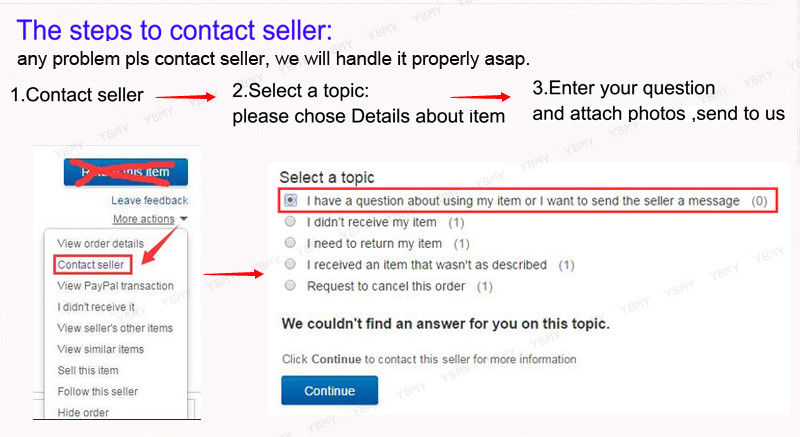
1. Any questions, pls. contact us via ebay message or email us.We will reply your message within 48 hours. If you do not receive our reply within 48 hours, pls. post a message again because sometimes our message system may block some emails.
2. If you are satisfied with our service, pls. kindly leave us a positive feedback and give us the Detailed Seller Rating with all "5 " in very area
3. Our aim is to provide Level Customer Service, your recognition will encourage us greatly and serve you better. We strive to keep all our customers satisfy.
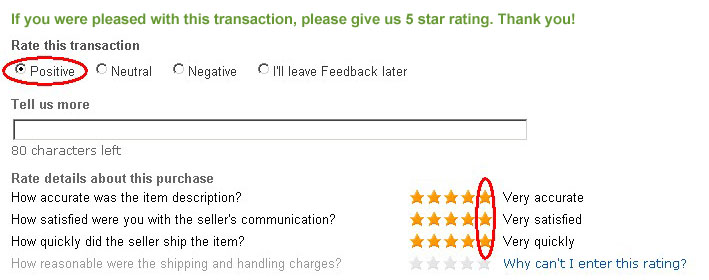
We will do our up most to exceed your expectations in customer service, communication and dispatching of your orders.
|